“The Underground Asset Register demonstrated that technology is not a barrier but an opportunity”


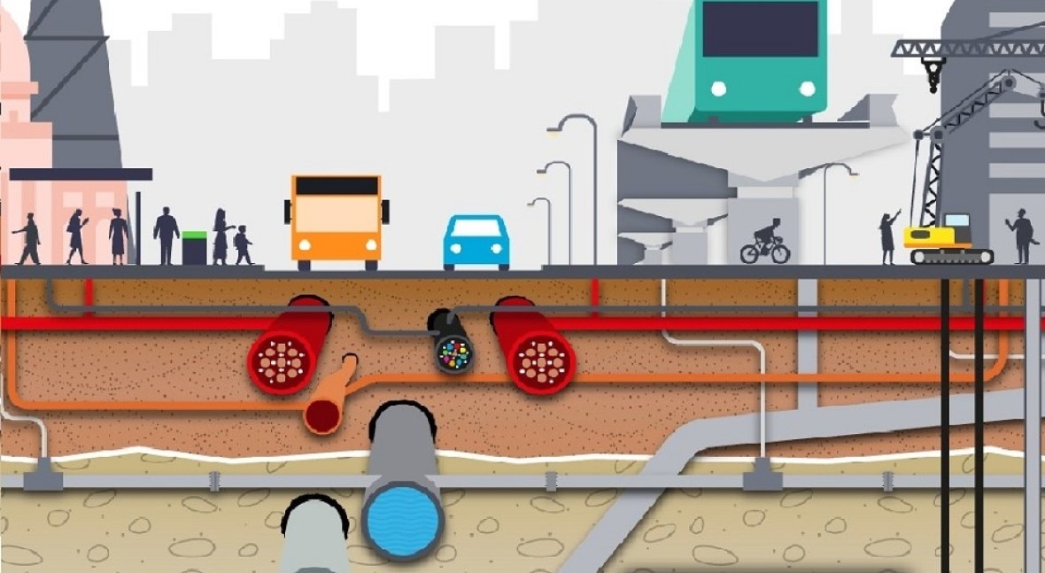
The National Underground Asset Register (NUAR), a digital map of utility assets under the ground, promises to make planning and executing excavations much easier for underground asset owners and save the UK economy billions, as just the economic costs of utility strikes alone are estimated at £2.4 bn a year.
Every seven seconds a hole is dug to access pipes and cables for repairs, upgrades and installations in the UK, estimates the Geospatial Commission - part of the UK government's Department for Science, Innovation and Technology. The National Underground Asset Register (NUAR) was created to streamline the data-sharing process between asset owners and excavators, reducing the number of utility asset strikes and promoting efficient management and maintenance of underground assets. The concept was initiated during Northumbrian Water Group's Innovation Festival in 2018, and has since been developed by a number of partners and turned into a reality by the Geospatial Commission. In this interview with Neil Lloyd, Service Adoption Lead, National Underground Asset Register at the UK Geospatial Commission, we learn more about the current status of this initiative that can transform the way we install, maintain, operate and repair buried infrastructure.

Please tell us briefly about your career path and your current involvement with the National Underground Asset Register (NUAR).
I joined the NUAR programme in February 2022 and in that time, I’ve been fortunate enough to work on various aspects of the programme. This has included engaging with stakeholders at the very start of their journey to explain the value and benefits of the programme, through to working on the policy and legislative requirements that will underpin it.
Currently, I’m leading on service adoption which involves ensuring organisations have the information they need to start using the service at the earliest opportunity. The minimum viable product (MVP or first version of the service) is currently available to asset owners who are fully signed up and their supply chains. We are encouraging early adoption as this allows users to provide invaluable feedback to the NUAR team on the service and its features, which helps us make it even better. Additionally, it allows users to provide feedback to their own organisations on the value and benefits of the service, and make plans to improve existing business processes through the full adoption of NUAR once it is fully operational.
Before joining the NUAR team, I worked for a large media organisation working on heritage BBC brands. I’m also a qualified barrister which has played an important part in facilitating the rollout of our asset owner legislative framework and understanding the process of converting our policy into actual legislation.
Can you give us an update on the rollout of the NUAR?
In 2019-20, two pilot projects were carried out in North East England and London to test the feasibility of creating a national map. Following the pilots, a phase of work began to address challenges and bring together various stakeholders. A data sharing framework was created to support voluntary data sharing and a Data Model Governance Group was established to create the NUAR data model and test it with data from all pilot participants.
We are encouraging early adoption as this allows users to provide invaluable feedback to the NUAR team on the service and its features
After addressing the challenges identified through the pilots, a competitive invitation to tender was launched in late spring 2021. AtkinsRėalis was appointed to lead the delivery of the new service and work commenced in September 2021.
In the first year of the programme, the team engaged extensively with asset owners and other stakeholders, finalised the legal framework underpinning the NUAR programme, began development of the platform, participated in the development of the Open Geospatial Consortium Model for Underground Data Definition and Integration (MUDDI), ran a public consultation on the potential of legislative reform and the proposed future operating model of NUAR to maximise the benefits to the UK economy, and identified key milestones towards achieving the intended benefits.
A data sharing framework was created to support voluntary data sharing and a Data Model Governance Group established
The NUAR programme has recently celebrated two years since work commenced on the platform and significant progress has been made. The NUAR minimum viable product (MVP) has been launched and enhanced and is now available to participating asset owners and their supply chains across England and Wales and is on track to go live in Northern Ireland this spring. The MVP includes all core functionality and capabilities to meet the ‘safe dig’ use case, allowing users to both plan for future adoption and provide valuable feedback to enhance the service further.
The MVP includes data from 186 organisations across the whole of England and Wales, including all of the major energy and water providers, such as Welsh Water, Cadent Gas and UK Power Networks, several major telecommunications companies, including CityFibre and Virgin Media O2, as well as smaller providers of these services, transport organisations and local authorities. This means that together with the Scottish Community Apparatus Data Vault, all areas of Great Britain are now covered by a standardised digital service for sharing and accessing subsurface utility data.
The team continues to develop a sustainable service that will increase efficiency, reduce asset strikes and disruptions, and provide opportunities to increase benefits further.
 has been launched and includes all core functionality and capabilities to meet the “safe dig” use case") The NUAR minimum viable product (MVP) has been launched and includes all core functionality and capabilities to meet the “safe dig” use case
The NUAR minimum viable product (MVP) has been launched and includes all core functionality and capabilities to meet the “safe dig” use case
Can you tell us about the technologies used and challenges with delivery such as data sharing and integration?
From our initial feasibility pilots in 2019-20 to the launch of our minimum viable product across England and Wales, a consistent finding has been the immense opportunities that geospatial technologies afford to improve how underground infrastructure data is shared and accessed. As those in the water sector are well aware, current processes rely heavily on the sharing of individual PDF drawings, which vary in scale, content, and style. This risks the plans being misinterpreted while also making it harder for excavators to compile drawings as per HSG47.
These drawings are also received on different timelines. For example, it currently takes approximately six days for a requester to receive and process all the data they need to safely carry out an excavation, with each organisation providing a PDF showing only their assets. In cases of emergency work, such as a burst water main, following this process completely is simply not feasible - workers are digging without all the data the use of modern technology could otherwise make available.
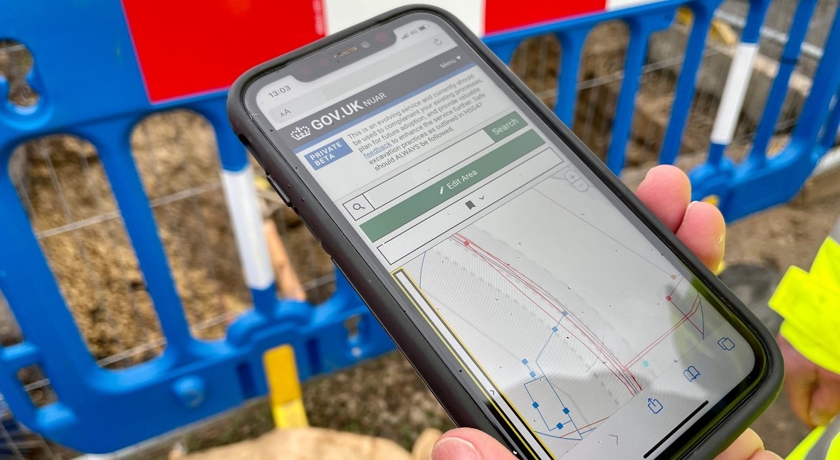
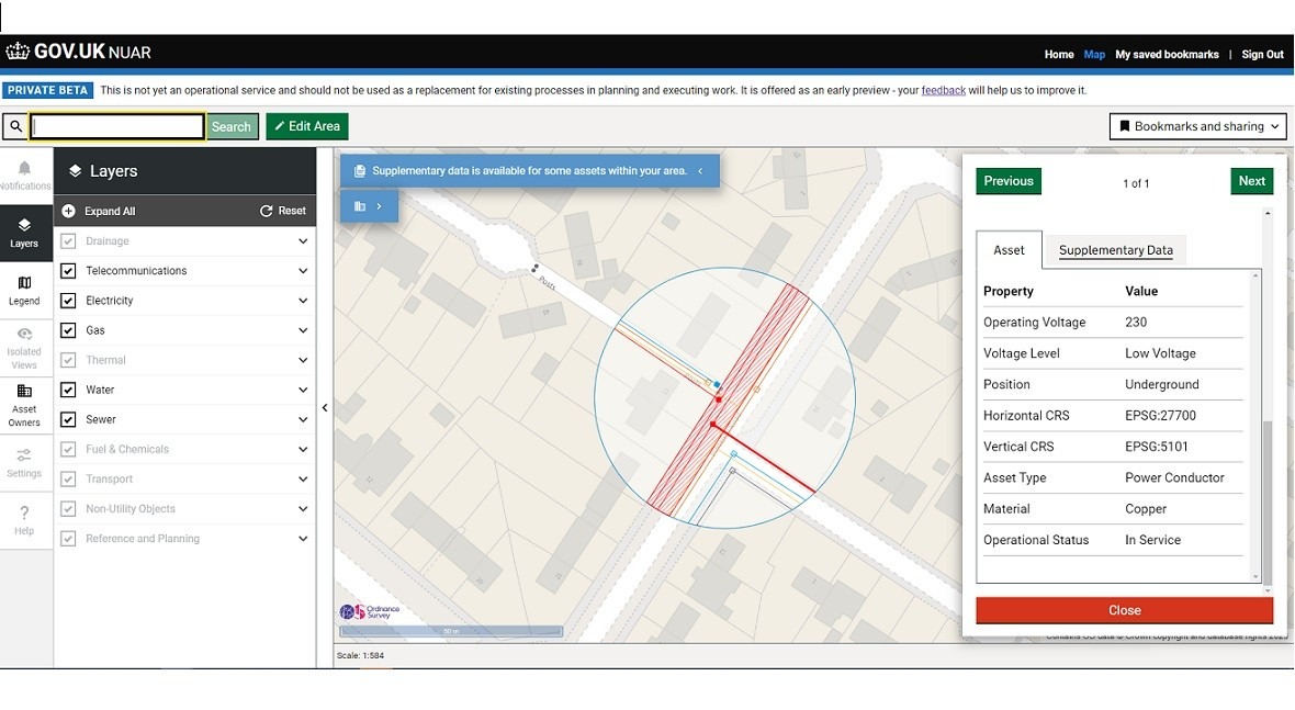
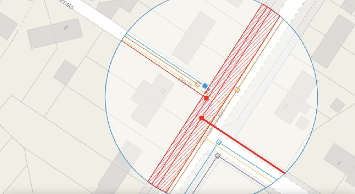
NUAR leverages geospatial technologies, allowing asset owners to upload their data digitally or via API for others to access. It also includes a web map interface which gives planners and excavators an interactive, standardised, and immediate view of buried assets at a given site. Instead of six days, NUAR makes data available in circa 60 seconds - 24 hours a day, 365 days a year. In addition to this, it includes a number of audit and access control measures to ensure data is readily available to workers, while also safeguarding against misuse.
A key challenge is always the standardisation of data - as the data was created over decades and varies significantly in terms of its form and structure. In our pilot phase, we worked closely with asset owners to produce a ‘harmonised’ data model which allows users to access standardised data whether in Newcastle or Cardiff . We based this model on an emerging international standard - the Open Geospatial Consortium’s Model for Underground Data Definition and Integration or MUDDI, which we also helped to develop. Use of this standard aligns our model with best practices, while also creating opportunities for asset owners to make improvements to how their data is held at source.
The success of our technical build is owed to the feedback we’ve received directly from users. We intentionally adopted an incremental approach to delivery, which enables us to gather early feedback from users and continuously enhance the service as we move forward. We ask users to continue to tell us what they think.
What measures are in place to ensure data accuracy, reliability, and security within the NUAR?
In cases of emergency work, such as a burst water main, workers are digging without all the data that technology could otherwise make available
We recognise that data is not perfect, with much of it created decades ago. To address this, NUAR includes clear metadata so users are aware of its provenance. It also includes information to remind users that accessing data is only one step in the safe dig process, it does not replace HSG47 and other safety guidance. To promote the incremental improvement of data, NUAR includes an “observation” feature, or a function that allows workers in the field to report inaccuracies in data or assets whose owners cannot be identified. We plan to work closely with the asset owner community as we develop this feature further. We also provide feedback on asset owner’s data through our data transformation service which helps them understand how they can improve their data before it even gets into the hands of users.
We have worked with asset owners, and security stakeholders such as the National Cyber Security Centre and National Protective Security Authority to ensure that NUAR is a secure platform equipped with comprehensive security controls. These controls safeguard data while allowing role-based access to the necessary information to support safe digging practices.
Can you comment on the expected benefits, in particular for the water utility sector?
The UK has approximately 4 million kilometres of underground pipes and cables, with 60,000 accidental strikes annually, costing the economy £2.4 billion and posing risks to worker safety. NUAR is expected to deliver over £400 million per year in economic growth through increased efficiency, reduced asset strikes, and fewer disruptions.
Instead of the 6 days it takes to receive and process the data to carry out an excavation, NUAR makes data available in circa 60 seconds
Upon completion, NUAR will provide access to data from over 700 organisations on the location of underground utility assets. This data will be available via a secure platform, initially to asset owners and their supply chain, leading to efficiencies in data sharing, planning of excavation works, and fieldwork. Planners will gain immediate access to a comprehensive view of underground utility assets, leading to more efficient planning of excavation works.
Workers in the field will have a richer view of buried assets, resulting in safer and more efficient work performance. Regular feedback, on the data in the platform from workers in the field, will improve data quality over time. NUAR will also publish a harmonised data model based on an emerging international standard, allowing contributions to data standardisation and improvement.
Efficiency has been baked into NUAR from the very start. As such, the platform will reduce the time it takes asset owners to share their data, it will reduce the time for excavators to receive and collate the data they need to commence work, it will help to reduce asset strikes and it will reduce disruptions for both citizens and businesses due to the time required to carry out roadworks and in reduced asset strikes. The emerging service also improves worker safety in underground operations by granting immediate secure access to location data for the privately and publicly owned infrastructure below ground.
Benefits to asset owners include, and are not limited to, savings from reduced utility strikes, reduced costs of sharing data, and on-site efficiency improvements.
Could you share any feedback from users and success stories?
We encourage organisations and users to provide feedback, from across the industry, with our most recent quantitative and qualitative feedback detailed below:
- Users rate the NUAR service 8.0 out of 10.
- User likelihood to recommend NUAR to a colleague is 8.8 out of 10.
- “The immediacy with which the asset data is displayed is an enormous improvement on the previous methods by which the information was acquired. Where previously, each asset owner would be approached individually, using NUAR allows us to instantly gather information from all parties and have it displayed together on one platform.” Edward Hobbs, Housing Growth Officer, Lewisham Council.
- “We are using NUAR probably every day, I would struggle to find a fault with it. If our old system was a horse and cart, NUAR is an F1 car.” Brian Weatherall, Drainage and Coastal Protection Manager, Durham County Council.
- “NUAR will be a game changer for health and safety in the construction industry, which all those that have been involved with it so far within Esh are in agreement with. Being able to access this information around the clock, and to also capture unchartered service information, is a huge step forward.” Norman Barnett, Framework Director at Esh Construction.
- “When we find that assets are not in the place that we thought they were, the ability to push back information to the central repository and have this information available for everyone’s benefit, as opposed to it sitting in silos, is very exciting for the industry.” Shelley Copsey, Co-Founder & CEO, Fyld.
What is the Geospatial Commission’s vision to ensure a sustainable service in the future?
NUAR is a complex programme as it involves bringing together data from 700+ organisations working in different sectors of the underground asset industry. These organisations all hold their data differently, which presents unique challenges when seeking to make it available to others in a standardised form. To us, the sustainability of the long-term service is what’s always at the forefront of our minds. That’s why we spent time working with asset owners to agree on a harmonised data model based on an emerging OGC standard - MUDDI. This creates a common “language” upon which repeatable data transformation and upload processes can be built.
In addition to this, in order to ensure users have access to the data they need when they need it - and in order to deliver a sustainable service, we are currently working to update existing legislation across England, Wales and Northern Ireland.
Finally, feedback from users helps us to continuously improve the service to ensure if there are any pain points, we are able to address them quickly to make the service better. It is also important to us that workers have access to all the data they need through the service and that the data remains up to date.
Are there any learnings so far that might be useful for similar underground asset initiatives in other countries?
The challenges associated with subsurface infrastructure data access are not unique to the UK. Most countries face the same challenges - e.g. data held by different bodies, created over decades, of varying degrees of quality, etc.
Success requires addressing concerns related to security, commercial sensitivities and liabilities with asset owners and future users
NUAR has demonstrated that technology is not a barrier but an opportunity. However, to find success, legitimate concerns related to security, commercial sensitivities and liabilities must be addressed. Our success to date has come from working with asset owners and future users on these issues (not just on tech) - individuals who understand their work best and are best able to identify and contribute to solutions that meet needs.
A cross sector data sharing service of this size cannot be delivered by any one organisation in isolation - it requires collaboration. NUAR demonstrates how this can be done.
We’ve also engaged with individuals from previous projects such as VISTA, Mapping the Underworld, Project Iceberg and HADES, as well as from those who have created similar services such as the Scottish Roadworks Commissioner VAULT system and operational systems in Belgium, Germany and the Netherlands.
Additionally, NUAR is of significant interest to other countries such as Canada, Singapore, Hong Kong, New Zealand, Australia, USA and Switzerland – as the opportunities that NUAR is capitalising on in the UK are replicated across the world.