Hunter Water, a State-Owned Corporation (SOC) based in Australia, is working alongside partner Detection Services, to expand Rezatec’s ground-breaking Dam Monitoring service across Chichester Dam.
Providing water to nearly 600,000 people in New South Wales, with over $2.9 billion in assets, Hunter Water’s ‘Towards 2024 Strategy’ focuses on ‘delivering sustainable, resilient and valued services’, along with ‘building a high performing and resilient organisation’.
“Using Rezatec’s Dam Monitoring technology aligns perfectly with our strategic objectives to increase digital services and improve the delivery and adoption of technology. Dam Monitoring enables a significant increase in the frequency and accuracy of monitoring for both Chichester Dam and Grahamstown Dam,” comments Daniel Turnbull, Dam Safety Engineer at Hunter Water.
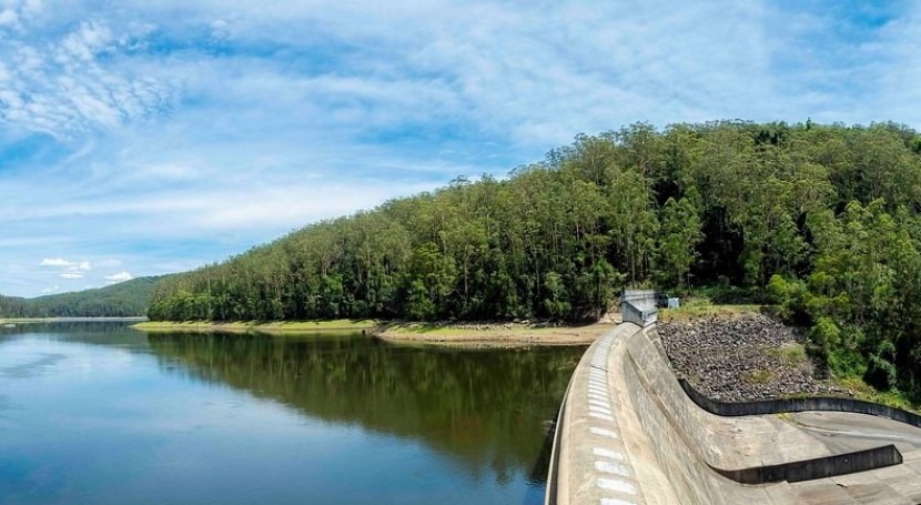
Supplying nearly 35% of Hunter Water’s potable drinking water supply, Chichester Dam is a 44-metre-high mass gravity concrete dam, curved in plan, with a 262-metre crest length and a centrally located spillway. At nearly 100 years old, the dam was originally constructed between 1918 and 1926, with the first water supplied in 1923. The dam has been upgraded throughout its life-span, with the most significant works completed in the early 1980’s, when an enlarged spillway, now 112 m in length, was constructed and 93 post-tensioned anchors were installed in the dam wall to reduce the risk of overturning.
“Due to the steep, heavily vegetated terrain in the vicinity of Chichester Dam, deploying traditional survey techniques are difficult, time consuming and costly,” adds Daniel. “Traditional surveys are currently undertaken for the site on a two-yearly basis in accordance with regulations.”
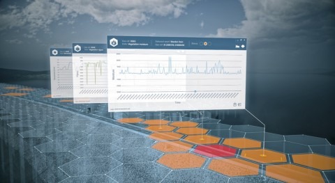
To enhance public safety and understand Chichester Dam’s behaviour, Rezatec’s Geospatial AI initially interprets three years of historic satellite data to create a retrospective analysis. This first step establishes a baseline trend of what is ‘normal’ and what isn’t.
"Here at Detection Services, we are pleased to see the extended use of Rezatec’s Dam Monitoring technology, boosting the number and quality of insights for our clients,” Chris Evans, General Manager at Detection Services commented. “Our long-term partnership with Rezatec allows us to continually challenge traditional methods and deliver highly targeted outcomes."
Daniel and the team at Hunter Water then receive monthly updates, using data collected at six-to-twelve-day intervals, to flag and locate any arising issues, down to a few millimetres of displacement. In addition to monitoring precise structural movements, the satellite data analyses vegetation moisture and vigour to pick up indicators of seepage.
“The expansion of Rezatec’s Geospatial AI to include the monitoring of Chichester Dam builds upon the benefits that are being realised at Grahamstown Dam, delivering value by providing an increased level of monitoring in a cost-effective manner,” said Daniel.