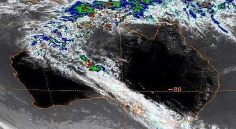


In the first week of 2023, slow-moving Tropical Cyclone Ellie dropped 800mm of rainfall, flooding the Fitzroy River in Australia’s northwest. Local residents were cut off from food and other supplies, leading to their evacuation by two military transport aircraft.
This was one of Western Australia’s worst flooding events, and it was fed by a weather pattern that has caused an almost doubling of rainfall in this part of the world over the last 70 years.
Alongside changing temperatures, changing patterns of rainfall have always been a matter of intrigue and concern.
The northwest region of Australia, with its vast and diverse landscapes, has seen a massive increase in rainfall since the 1950s. This increase has been difficult to explain, but our new research may have finally uncovered the cause.
The wet season is getting wetter
Northwest Australia is located within the tropics, which means there are two main seasons in the year – wet and dry. The wet season starts in November and finishes in April, and provides around 90 per cent of the yearly rainfall, while the dry season lasts from May to October.
At some point in the wet season, usually around December, the winds change from the east to the northwest, bringing large amounts of moisture and rainfall – the monsoon has started.
Rainfall in the monsoon is more intense, more persistent and more widespread. And the amount of rainfall from each monsoon has been increasing since the 1950s, with some areas now receiving an extra 200mm of rain per year.
Most other regions in Australia, in stark contrast, have been drying.
So we set out to understand why rainfall has increased so much in northwest Australia. We found the cause to be changed we have observed in a pulse of cloudiness and rainfall known as the Madden-Julian Oscillation (MJO).
For this analysis, we used a network of rainfall stations that the Bureau of Metrology has been operating for over a century – providing us with long-term rainfall records. Then, to understand the background atmospheric changes that may have led to this cause, we used output from satellites.
The MJO is a rainfall generator
The journey of the MJO begins in the Indian Ocean, where it travels eastwards across the north of Australia, moving at around 20km/h. As the MJO passes over northern Australia, the chance of extreme rainfall triples (with extreme rainfall defined as the chance of weekly rainfall being in the top 20 per cent).
The MJO continues towards South America, finally decaying when it reaches the cool waters of the Eastern Pacific. Overall, the journey takes between 30 and 90 days.
On its journey, the MJO aids in the formation of tropical cyclones by acting as a source of moisture and updrafts. This was the case for the flooding in the Fitzroy River, where the tropical cyclone initially formed while the MJO was over northern Australia.
Similarly, the record-breaking North Queensland floods in early February 2019 were also found to be intensified by the MJO. And besides extreme rainfall events, the MJO can also worsen heat waves in southern Australia by sucking moisture away from the region.
The Indo-Pacific warm pool is growing
The path of the MJO goes directly over the Indo-Pacific warm pool. This is the largest body of warm waters on the planet, where sea surface temperatures permanently exceed 28°C. The warm pool is centred around Indonesia and extends eastward and westwards into the Indian and Pacific Oceans.
Warming from greenhouse gases, such as CO₂ and methane, has caused the Indo-Pacific Warm Pool to double in size. On average, the warm pool has been expanding by the size of Victoria (280,000 square kilometres) each year since the year 1900.
The expansion of the warm pool has resulted in the cycle of the MJO becoming ‘warped’. The MJO is speeding up over the Indian Ocean and slowing down over northern Australia.
The MJO now spends five to six more days over northern Australia per cycle, and we found that this is the cause of the increasing rainfall trend.
To do this, we explored how rainfall trends have been changing with and without the presence of the MJO. We found that when the MJO is absent, the rainfall in northwest Australia has actually been decreasing in many areas in the northwest. The increase in rainfall was only present when the MJO was over northwest Australia.
The MJO has led to more days with rainfall and more total rainfall each monsoon. This trend is so large that in some regions the rainfall associated with the MJO has been increasing by 15-25 per cent per decade.
The rainfall associated with the MJO has not become more intense; rather, because it spends more time over northwest Australia, there are just more days with rainfall.
While this rainfall trend has been observed since the 1950s, in our study we were only able to analyse this relationship back to the late 1970s, as accurate detection of the MJO requires satellite data.
It may keep getting wetter
Climate simulations show that the MJO may continue to drive increasing rainfall in northwest Australia. Under a high emissions scenario, where there is little effort to reduce greenhouse gases, northern Australia will receive 12 per cent more rainfall on average across northern Australia.
All of the rainfall increase is expected to be due to the MJO, with less rainfall occurring when the MJO is not present.
However, under low-emission scenarios, the pattern stabilises and the predicted rainfall increase almost disappears.
Future trends in rainfall in this region remain uncertain in climate model projections.
The increasing rainfall trends observed in northwest Australia have significant implications for the region’s ecosystems, communities, and industries. Understanding the cause of these trends is important for the health of ecosystems and agriculture in northwest Australia.