

La Gomera (Canary Islands – Spain) has 24 large dams spread over its steep terrain of 369 km². There are 24 dam walls over 15 m high from their lowest foundations to the highest point of their crests. The six oldest dams on the island (La Vieja, Antoncojo, Tapahuga, Dama, Cascajo and Benchijigua) are heritage treasures of great cultural interest. In particular, the Tapahuga dam is the one with the greatest potential as a place to contemplate the water culture of the first half of the 20th century.

Introduction
It is stated that in isolation hydraulic works cannot be fully understood. Therefore, the relevance of a large dam cannot be understood exclusively from the field of technology, but also from its relationship with the territory and history. If large dams are structures combining elements of geography, engineering and agriculture, in La Gomera (the island with the largest number of dams per square kilometre), the old reservoir walls are some of the best examples that exist of this remarkable combination of 20th century. They were built because farmers decided, long ago, to construct them in the deep ravines of the island to capture, store and transfer water to their farms, in a pact with the territory. These treasures deserve to be contemplated from the foot of the dams, such as the old Tapahuga Dam, an engineering monument with aesthetic, symbolic and scientific value, and which produces fascination and amazement among visitors. It is an ornament with an almost vaulted appearance, whose cultural possibilities are wide ranging.

The object of this study is the Tapahuga Dam, but first, we are going to expound on the philosophy behind the great dams built in La Gomera and their origins.

The Cocos Dam (1914), known as La Vieja, is the masterpiece on the island because of its antiquity, history and location. The purpose of the project was to provide water for a large and fertile farms located at the mouth of a narrow and straight ravine that was four km away. This is the second oldest dam in the Canary Islands and is a work of stone masonry with lime and sand mortar with the upstream face being covered with hydraulic plaster. The dam is 18 metres above a riverbed and has two unique counter-dams on a rocky promontory. Initially, it was designed with a curved surface, but when the wall protruded over the rocky promontory on its left side, its design was modified with a sharp upstream break. Buttresses were placed in the area of the break later, possibly after an incident with a full reservoir. At the end of the reservoir, a beautiful sieve dam was built.
Subsequently, private initiatives constructed the large dams of Antoncojo (1920), Tapahuga (1933), La Dama (1944), Benchijigua (1947), Cascajo (1947) and Cardones (1953) in the southern ravines. According to the observations of the engineer Manuel Alonso Franco, all these large dams have the general characteristics of the classic constructions of the Canary Islands: lime masonry, curved ground plans, triangular sections with upward facing water and a downward slope of water, which is insufficient to be considered as pure gravity. These dams often lack a spillway or have a small side spillway without an outlet.
As for the large publicly-owned dams, they all date from the second half of the 20th century. The Llano de la Villa spillway (1952) was built in a very narrow ravine of only 10 metres depth. Other masonry dams are Garabato (1953), Palacio (1954), Iscagüe (1957), Palmita (1958), Quintana (1961) and Liria (1967). In 1964, the engineer Manuel Alonso Franco wrote in his report that these large dams were more modern, gravity with a straight ground plan, masonry with cement mortar and all of them had a large fixed side spillway.
In the 1970s and 1980s (20th century), five more large dams were completed or built. Chejelipes Dam (1970) is made of masonry concrete, while La Encantadora Dam (1973) and Los Gallos Dam (1978) are made of concrete. The only two rockfill dams that were built on La Gomera are Mulagua (1981) and Amalahuigue or Las Rosas (1983). Finally, in the early 1990s, the concrete spillway dams of Los Tiles, La Cuesta, Ariala and Macayo were built. Consequently, La Gomera is the island with the largest number of reservoir dams per square kilometre, with 24; although the island of Gran Canaria has a higher total number: 73 large dams.
Tapahuga Dam
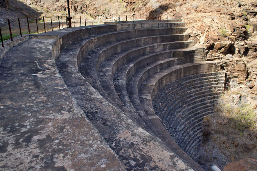
In 1962, the Tapahuga Dam was registered by the Spanish Ministry of Public Works in its Official Catalogue of dams with a height of more than 15 metres. It is located on the island of Gomera in the Barranco de Tapahuga. Its year of completion was 1933. The dam is a gravity type, curved profile, height without foundations of 15.50 m, masonry and a reservoir capacity of 0.124 hm³. A photo of its wall was added to the 1970 Inventory of Large Spanish Dams (SPANCOLD), while its standard profile was included in the 1973 Inventory (MOP). Tapahuga was mentioned in two inventories of the 20th century (1986 and 1991), but then disappeared from the 2006 Spanish Dams Inventory. However, it remains in the World Register of Dams.

At the beginning of 1964, the Dam Surveillance Engineer Manuel Alonso Franco, in charge of the Canary Islands, visited the Tapahuga Dam in the company of José Luis Fernández Casado, Chief Engineer of the 8th Negotiation Office of the Central Water Commission. The general data for the description of the dam were provided by the Canary Islands Water Commissioner. Due to its great historical interest, we reproduce below the most relevant paragraphs of Tapahuga's visual recognition carried out by the two engineers.
“It is gravity fed with a very curved ground plan and a height of 15.50 metres above the foundation. The upstream slope is vertical, and the downstream slope is 0.65. This dam was built in two stages: the first one is made of masonry and the second one is made of concrete. The water down face is staggered with larger steps in the concrete area. The dam has no spillway, pouring over its crest the few times it is filled. There are three closed water intakes with gates that are operated from the crest. It also has a bottom gallery for cleaning the glass, although from the number of landings it may never been used. On the day of the visit, the reservoir had about 15,000 m³ of water, no filtration through its walls was visible. Its structure gives the impression of great solidity and safety due to its strong curvature and placed in a narrow ravine of very compact volcanic rock.”

In 1966, an internal report on Canary Island dams stated that most of them were of old construction, without visiting galleries, masonry drainage, bottom drainage and even surface spillways; and that the Authorities were concerned about the safety of these constructions. In his desire to achieve better control and safety in this type of structure, Manuel Alonso Franco carried out a new inspection in 1968 of several dams in operation. Tapahuga was not among the dams visited and during the following three decades engineers only focused on the Palmita Dam (Agulo), because its dimensions were considered unsafe, and on other dams, such as Chejelipes, Encantadora, Iscágüe, Mulagua, etc.
At the beginning of the 2000s, the Directorate General for Water of the Government of the Canary Islands prepared two inventories of large dams in the Canary Islands: one with general data and the other focused on the operation and safety of the dams. Subsequently, the Directorate drew up safety regulations for large water storage infrastructures in the Canary Islands (2005), which were never approved. In the two inventories, the general characteristics of the Tapahuga Dam repeat the data from the 1991 Inventory of Spanish Dams (with a height of 16 m) and the standard profile from the 1973 inventory. It was subsequently discovered that the dam has no technical arch and nor does it have downstream elements that could potentially be affected in the event of its incorrect operation or failure.
In 2008, the Island Water Council of La Gomera commissioned a project to repair and put into service ten large public dams. The success of this work led the Directorate General for Water in the Canary Islands to commission the drafting of a study to evaluate the control and monitoring requirements of the archipelago's dams with the aim of ensuring good management of large dams. In the report on the Tapahuga Dam, the first thing that stood out was its proximity to the Jardín Tecina Hotel. There were other aspects such as its location in the Tapahuga Ravine, upstream of the Santiago Beach Wastewater Treatment Plant. Moreover, the access to the dam is via a dirt track that ends 100 meters from the wall; and then, after crossing the riverbed, access to the dam's crest is via a path on the left bank. Subsequently, the engineer detailed the body of the dam (gravity, height 16 m and crest 86 m long and 2 m wide with metal railings), the spillways (spillway, bottom gallery and water inlets) and the absence of drainage and auscultation devices. With regard to the body of the dam, the lower part is made of masonry and the upper part of concrete, with the upstream face vertical and the downstream face staggered (with concrete steps having larger sections than the masonry ones). The 1973 standard profile was also included.
As regards the spillway, in 1964, Manuel Alonso Franco stated in his report that the dam did not have a spillway (crest spillway), as many other Canary Island dams with a crest recess; but in 2009, a spillway was established in the central part of the dam, spilling freely over the crest and the body of the wall. Thus, Tapahuga is a vault-like spillway.

Finally, in his doctoral thesis, Masonry Dams in Spain (2011), the engineer Diego Saldaña Arce provided a more in-depth analysis of Tapahuga: “The dam was built in two stages, clearly differentiated by the material used. The lower area consists of an ordinary masonry mass, which was crafted in the walls to form a faceted masonry. The downstream face is stepped but, unlike what has been observed in other dams on the island of Gran Canaria, no masonry was used to form the steps, but rather a laborious masonry rig. To make this masonry, stones of different sizes, slightly carved, were used to form horizontal steps. To do this, it was necessary in some areas to rig several masonry walls vertically to equal the height of others, shaving the joints with stone and smaller edges, so that the general appearance of the masonry acquires an air similar to the opus incaertum of Roman walls. Later, a second construction stage was developed in which the massif and the walls were built with concrete. Probably with a degree of internal masonry. The time of construction of the upper area is not known, and it is logical to think, because of the material used, that it corresponds to the 1950s. The condition of the dam is that observed during the inspection carried out by the Dam Surveillance Service in the mid-1960s. The profile of the dam is gravity, with a vertical slope upstream and a variable slope downstream. The lower area of the latter has a steeper slope than the upper area. The current maximum height above foundation is about 16 m. The height initially intended is not known, so the safety of the original profile cannot be interpreted. The change in slope of the upper area of the downstream face may be due to an attempt to finish off the dam with a lower height than initially planned. The dimensions of the profile convey a feeling of great security, which is enhanced by the strong curvature in plan, and its location in a narrow ravine of very compact volcanic rock. The length of the crest is about 86 m, reducing considerably the development of the dam in the lower area.

The fit of the dam’s ground plan was not adequate, since the lower part of the right abutment comes out of the natural downstream boundary, an issue that had to be solved with a strange break in the wall (it is difficult to understand a failure in the layout of the lower level of the dam, which makes it possible to assess some possible singularity of the natural downstream boundary in this area). The dam does not have a spillway, the spillages being carried out directly from the crest, which could explain the absence of imposts and the staggering of faces (although the staggering seems to correspond more to the usual construction criteria of the Islands).
The dam has a lower cleaning gallery which, due to the degree of tethering of the reservoir, was probably never used. This has led to a large decrease in the capacity, which in the 1960s had been reduced from 0.124 hm3 to just 0.040 hm3. It also has three water intakes at different heights regulated by gates from the crest, which seem to have been modified by the reservoir's silting up. Additionally, one of the lower inlets is regulated from the downstream wall by means of a small diameter cast iron tap.”
Tapahuga Dam: An expression of traditional dam building art
We do not know what was imagined in the initial project that served as the basis for obtaining the building concession, but 1933 must have been the year of its Final Recognition Act (an unlocated document). The initial wall of the Tapahuga was an unfinished massif of ordinary masonry with lime mortar, gravity type, curved ground plan, downstream facing staggered and upstream facing vertical. This dam was built more than 90 years ago in a very narrow gorge of the ravine, only 100 meters away from the nearest agricultural land (banana plantation). It had a sharp curve above the foundation, at the foot of the river, hence the breaks in the masonry in its abutments (especially on the right).
The unfinished Tapahuga dam was built to capture and store water (from the ravine) for irrigation of farm estates at the bottom of the ravine and in the interfluve of Tecina (Hotel Jardín Tecina area). It must have been in use for some years until it was later enlarged. This addition consisted of a body of masonry concrete with a very curved profile and a more extended stepped downstream slope than in the original dam, thus achieving a significant reduction in the amount of factory. Without a doubt, the Tapahuga Dam is one of the most interesting historical constructions in the Canary Islands and whose features and intricacies cannot be reduced to a small number of technical notes. Therefore, this dam together with the environment of the ravine produces strong emotions in visitors who come to contemplate and admire it.
None of the engineers, in their comments or impressions on the Tapahuga Dam (1964, 2009 and 2011), contributed anything about the waterproofing linings of the reservoir with lime and cement mortar, especially next to the dam abutments. In the Canary Islands, if the riverbed was permeable it was waterproofed, and the Tapahuga reservoir is another masterpiece of this ancient waterproofing. Nor was there any mention of the handcrafted staircase which, was built with dry stone blocks. The staircase allows access to the promontory of the left abutment and, from there, to reach the crest of the dam. Small, yes, but useful, beautiful and intact.
Another interesting phenomenon, difficult to observe, is the water diverted from the Roque de Tecina area. Indeed, the anti-water aerial photographs allow us to observe and analyse the white lines (gullies, pond channels, ditches and ravines) which, as a result of the diverted water, run through the territory until they reach the reservoir basin, next to the right abutment. This old phenomenon, which we now rescue, was restored and published by the Instituto Geográfico y Catastral, although with an error in the drawing: they collected the entrance of the waters to the Tapahuga Dam through the tail of the reservoir.

The sum of all these features has created a dam that is a work of art unique to La Gomera, and different from the rest of the large masonry dams built in the Canary Islands. And when one enjoys the privilege of viewing a panorama of such magnitude, before the evident reality of a work of art with an almost vaulted appearance, any visitor will feel the emotion of participating in its conservation, construction, exploitation and permanence. The Tapahuga Dam, due to its location in the lower section of the ravine and access track, gives visitors the chance to contemplate and admire the structure and its surroundings. The dam presents a viewpoint higlighting what was built by private initiatives in the first half of the 20th century. In other words, the Tapahuga provides a view of historical dam construction, captured in its two bodies, and a spillway, and with its functions still intact: storage of water and sediments.
The architect Eduard Callis states in his thesis Arquitectura de los pantanos en España, that "physically and symbolically, the dam plays in the league of geographical landmarks", and that "we want to get closer by entering the sensitive field of its presence" because "a dam is already noticed from afar".
Without doubt all the large old masonry dams built on the small island of La Gomera are geographical landmarks. An unfortunate report issued by the Island Council of La Gomera in 2016 on the Old Cocos Dam (1914 ) considered that the second oldest dam in the Canary Islands was a normal construction, without any kind of relevance, representing a common construction procedure to other dams in the Canary Islands built at the same time. However, there are many reasons to consider them as emblematic structures.
Tapahuga is a large dam accessible along a 925 m long dirt track that runs along the bottom of the ravine. From there, a path allows visitors access to the promontory that dominates the left abutment of the dam. From the top, visitors can enjoy the overwhelming and silent contemplation of the strong curve of the dam’s concrete crown, the contrast of its steps, the sinuous extension of the reservoir, the glass coating works, the imposing wall of the ravine until reaching the Punta de Tecina with its unique view.
The second option, after entering the riverbed to reach the foot of the dam is to contemplate the verticality of the wall, as well as its details: water intakes, steps (masonry and concrete), cleaning gallery, abutments, etc. There the visitor will also feel the narrowness of the ravine, the monumentality of the dam and the efforts of farmers to close it. At the foot of the dam, the visitor will also be able to perceive the scale of the surroundings and the contact between the dam and the land (rocky abutments), the height of the wall and the masonry and concrete.
Conclusions
Finally, it is worth mentioning that there is no coordinated management of the historical water heritage in the Canary Islands, nor is there any cultural recognition of our waterworks and their associations (mining and industrial heritage) on the same level as other heritage (archaeological, architectural, etc.). However, this work clearly shows that La Gomera is the second island museum of large dams in the Canary Islands and the Tapahuga Dam should be visited. Many aspects can be improved by means of minor adaptations to facilitate access to the dirt track, a modest car park, identification of the path to the promontory, creation of a path along the riverbed to the foot of the dam, signs, information and education. Indeed, the cultural potential of the Tapahuga Dam is varied.
References
(1964) SECCIÓN DE VIGILANCIA DE PRESAS. Informe sobre el estado de las grandes presas de embalse de La Gomera. Madrid.
(2015) CALLÍS FREIXAS, E. Arquitectura de los pantanos en España. Universitat Politècnica de Catalunya (UPC). Barcelona.
(2012) GONZÁLEZ GONZÁLVEZ, J. Construction of large dams in the Canary Islands. XXIV Congreso Internacional de la Comisión Internacional de Grandes Presas (ICOLD-CIGB) – Kyoto, Japón.
(2012) GONZÁLEZ GONZÁLVEZ, J. & J.C. SANTAMARTA CEREZAL. Singularidades y evolución técnica de la ingeniería de presas en las Islas Canarias. Revista de Obras Públicas 3530: 33-50. Madrid.
(2015) GONZÁLEZ GONZÁLVEZ, J. Registro de las grandes presas canarias en explotación (Islas Canarias). X Jornadas Españolas de Presas. Comité Nacional Español de Grandes Presas. Sevilla.
(2015) GONZÁLEZ GONZÁLVEZ, J. Registro de las grandes presas en explotación en la isla de La Gomera (Islas Canarias). X Jornadas Españolas de Presas. Comité Nacional Español de Grandes Presas. Sevilla.
(2019) GONZÁLEZ GONZÁLVEZ, J. Construcción de grandes presas en Canarias: la singularidad de Gran Canaria. Actas XIV Semana Científica Telesforo Bravo. Instituto de Estudios Hispánicos de Canarias. Tenerife
(2011) SALDAÑA ARCE, D. Presas de mampostería en España. Tesis Doctoral. Universidad de Santander.
