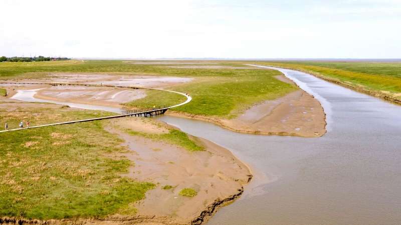
A quiet but constant crackling is in the air. It sounds like bubbles in a fizzy drink and accompanies anyone who walks along the wooden footbridge that crosses the Langwarder Groden, between the main dyke line and the summer dyke.
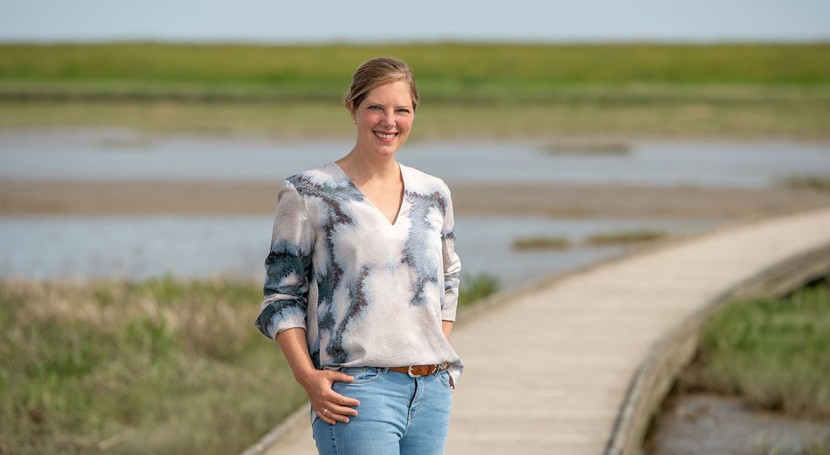
"That's the sound of thousands of tiny mud scuds bursting air bubbles in the mudflats," says coastal protection expert Dr. Leena Karrasch. She recommends that anyone who wants to see what a desirable future for Germany's North Sea coast might look like should visit this wetland area on the northern tip of the Butjadingen peninsula between the Jade Bay and the Weser estuary.
Reconciling seemingly conflicting interests
Since the summer dyke was reopened a few years ago, this has become a place where nature can freely unfold again under the influence of the tides. The salt marshes can act as natural buffer zones, providing protection from waves during storms, and are partly used as extensive pastures.

Between the former summer dyke (on the right edge of the picture) and the main dyke (on the left) a boardwalk leads through the Langwarder Groden. For Leena Karrasch (on the jetty in the yellow jacket), its renaturation, initiated as compensation for the expansion of the deep-water port in Wilhelmshaven, is a good example of climate adaptation on the North Sea coast. Credit: University of Oldenburg
A nature trail meanders across them. For Karrasch, a walk in the Langwarder Groden raises precisely the questions at the heart of her research: How can coastal and inland areas be prepared for the consequences of climate change—whether that means rising sea levels or extended periods of drought and heavy rain?
How do nature and society interact? How to shape decision-making processes so that they reconcile apparently conflicting interests and use synergies in the fields of water and coastal management, nature conservation and biodiversity, agriculture, policy, but also recreation and tourism?
Combination of various disciplines
These are questions that bring together natural and social sciences, just as Karrasch herself combines various disciplines in her own work. Her rather unusual academic pathway began with a degree in biology, after which she earned two Master's degrees at the Universities of Groningen and Oldenburg in the newly launched "Water and Coastal Management" double-degree program.
After completing her doctoral degree in natural sciences at the University of Oldenburg, she moved to the university's Department of Business Administration, Economics and Law, where she has been a post-doctoral researcher in the Ecological Economics working group led by Prof. Dr. Bernd Siebenhüner ever since.
The 37-year-old has also conducted research at the university's Center for Environmental and Sustainability Research (COAST) for over a decade.
Focus on transdisciplinarity
Karrasch realized early on that strategies for regional climate adaptation were what really interested her. She wanted to develop her research together with the people who decide which measures to deploy or are affected by them, so that society benefits directly from the results. The principle behind this, transdisciplinarity, combines scientific findings with their practical application, and is what makes her work at the university special.
Karrasch is currently involved in the large-scale transdisciplinary project "Gute Küste" ("Good Coast"). She also works in two other projects, has already completed five more, and has several others in the pipeline.
All these collaborative projects deal with water and coastal management and the consequences of climate change—and Karrasch's task is always the same: to build bridges between research and practice
At the once lowest point in Germany, there will soon be a lake again
The fact that she has a background in both natural and social sciences has proven invaluable for this intermediary role. "In the mutual exchange with regional experts, for example, I can draw on models from the natural sciences and additionally mediate internally between the disciplinary cultures—or work out a common thread for joint research proposals," she says.
The geographical focus of Karrasch's work is her home region—the North German coastal zone. "When I was doing my Master's degree, many of the students were studying the impact of climate change in distant parts of the world—mangrove forests in the tropics or Pacific islands under threat, for example," recalls Karrasch, who grew up in the town of Wilhelmshaven on Germany's northwest coast.
"But East Frisia is also affected," she reflected. However, efforts to adapt to the changing climate in the northwest region were largely limited to building and reinforcing dykes, she explains. "But there are other approaches, and I want to be part of it."
Take Krummhörn, a municipality with 54 kilometers of coastline situated near the estuary of the river Ems. In a project launched in 2011, Karrasch spent four years working with local experts in water management, nature conservation, agriculture, tourism and community politics to develop a strategy for sustainable land use.
Participatory research already shows effects
Not only did the Intergovernmental Panel on Climate Change in 2019 cite the findings in a special report on the state of the world's oceans. The strategy was also directly incorporated into the county's regional planning program in 2018. "That kind of thing usually takes a long time.
I was quite surprised and enthusiastic to see our participatory research make an impact so quickly," says Karrasch.
In the first stage of the project Karrasch, together with Oldenburg landscape ecologists Prof. Dr. MichaelKleyer and Dr. Martin Maier and COAST coordinator Dr. Thomas Klenke, had developed several future scenarios for the municipality of Krummhörn, of which one third lies up to 2.5 meters below sea level.
At present, its marshland is drained by a network of ditches and canals and is mainly used for agriculture and dairy farming. Karrasch then used maps to show where it would make more sense to focus on creating water storage areas—also considering the increasing frequency of droughts—and identified areas where waters with reed could be used for carbon capture and storage. She then presented strategies that were deemed practicable to the team of experts for discussion.
Experts assess feasibility
This approach of developing future scenarios and strategies on the basis of workshops, interviews and focus groups of interested parties is a key feature of Karrasch's work. By the end of the four-year planning process in the Krummhörn region, a concept designed together with the experts had been agreed on. It involves the creation of additional polders—retention areas that can be flooded in the event of heavy rain.
One example is the "Freepsumer Meer," which has been drained and used for agriculture since the 18th century. As the county Aurich stipulated shortly afterwards in its 2018 regional spatial plan, in the long term this could result in the creation of a new lake at the site that was long deemed the lowest point in Germany.
The value of this two-way transfer—in which scientists benefit from societal perspectives and local expertise and the region from scientific findings—is also apparent in another project in which Leena Karrasch was involved: the SALTSA project. A team co-led by Oldenburg hydrogeologist Prof. Dr. Gudrun Massmann and Siebenhüner analyzed the increasing salinization of groundwater associated with rising sea levels. Once again, Karrasch was in charge of facilitating the exchange of information with experts from the region.
Always talking to experts
"Waterworks, drainage associations, the Water Association Council of Lower Saxony—I talked to everyone who was involved with water in the northwest." When the project started in 2016, even these circles were not aware of the fact that groundwater can become saline even in a rainy region, Karrasch recalls.
"At first I felt really disheartened because hardly anyone was willing to discuss the issue." However, she documented perceptions, knowledge and learning processes of the stakeholders and found that over the five-year project period—and in particular after the unusual dry years from 2017 to 2019—awareness of the problem increased.
Drainage ditches cause salinization
The modeling performed in the SALTSA project made researchers and practitioners alike realize—to their own surprise—that drainage ditches are one of the main causes of groundwater salinization: the deeper the ditches, the greater the risk.
In the past, the focus had been on increased groundwater extraction. "This was one of those moments that shows how science can also disprove widely held assumptions," says Karrasch. Thus, the project "brought to the fore a completely new factor that had not been considered before"—and put the issue of salinization firmly on the agenda of the region's water management authorities, as well as Lower Saxony's recently published water supply concept.
Plea for natural processes
Karrasch's goal in both coastal protection and water management is a holistic perspective. "In general, we need to think less in terms of technical adaptation and work more with natural processes," says Karrasch, as she walks across the Langwarder Groden.
Is the international community's goal of limiting the rise in global temperatures to 1.5 degrees Celsius at all achievable? Karrasch has serious doubts, but is nevertheless optimistic that her two children will be able to "live good lives in the future—although no doubt differently from the way we live today." With the right approaches and strategies, regions can adapt to the changing climate, she stresses. "We humans will always find a way to deal with new situations."


