

A new study by the U.S. Geological Survey is reshaping how water managers think about PFAS contamination, and its implications stretch well beyond New England.
Published in Environmental Science & Technology, the research used a boosted regression tree model trained on 229 soil sample points across Maine, Vermont, and New Hampshire to predict background concentrations of PFOS and PFOA in shallow soils. Crucially, the contamination is not linked to industrial sources — it originates entirely from atmospheric deposition, PFAS travelling through the air and settling via rainfall, snowfall, and dry deposition, what scientists call "anthropogenic background."
Prioritise groundwater monitoring where soil PFAS looks clean, pH is high, and organic carbon is low
The headline finding is striking: the model predicts 73% of soils across the three states exceed New Hampshire's soil remediation threshold for PFOS, and 41% for PFOA. The single strongest predictor of elevated concentrations was not proximity to factories or military sites, but soil pH. Low pH soils retain PFAS; high pH soils release them downward.
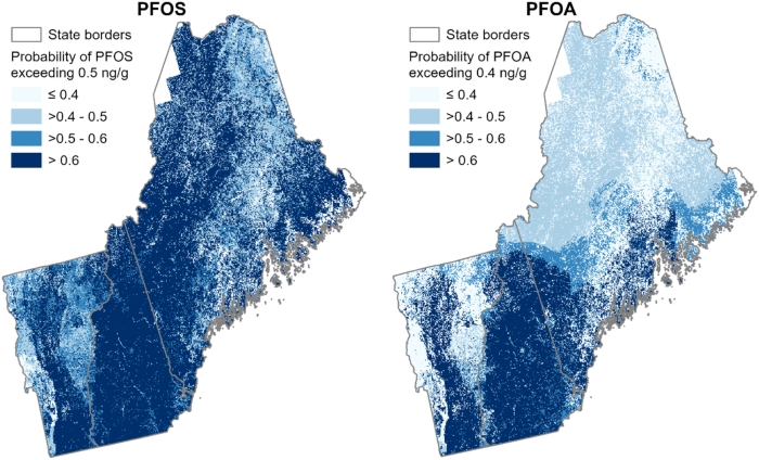
Predicted probability of PFOS and PFOA concentrations exceeding New Hampshire's soil remediation standards (0.5 ng/g for PFOS and 0.4 ng/g for PFOA) across Maine, Vermont, and New Hampshire. Darker blue areas indicate a probability greater than 60% of exceeding these thresholds. Source: Tokranov et al., Environmental Science & Technology, 2026.
That last point yields the study's most counterintuitive insight. Areas where soil PFAS levels appear low may actually pose the greatest risk to drinking water, because high-pH, low-organic-carbon soils allow PFAS to leach into aquifers rather than accumulate near the surface. Data from 435 private drinking water wells in New Hampshire support this: the proportion of wells where PFAS was detected was highest precisely where soil concentrations were lowest, though the study does not report at what concentrations PFAS were found in those wells.
Bedrock geology compounds the risk further. Calcareous rock formations raise soil pH, lower organic carbon, and feature vertical fractures that can act as direct conduits to bedrock aquifers. Analysing data from 435 private drinking water wells in New Hampshire, the authors found that the proportion of wells where PFOA or PFOS was detected was highest in areas overlying calcareous rocks specifically, reaching 66% for PFOA and 49% for PFOS, significantly above other lithologies.
For water utilities and regulators, the study offers a practical planning tool: prioritise groundwater monitoring where soil PFAS looks clean, pH is high, and organic carbon is low. The methodology is also exportable, since atmospheric deposition is a global phenomenon, making this a study the international water sector should watch closely.


