New, lower-cost help may soon be on the way to help manage one of the biggest threats facing the Great Barrier Reef.
That threat is pollution from land making its way downstream by way of the many rivers and streams that flow into coastal waters along the reef.
The size of the reef – which stretches for 2,300 kilometres along the Queensland coast – makes it extremely hard to get an idea of what’s happening in real-time.
Now, in collaboration with scientists at the Queensland Department of Environment and Science, researchers at the ARC Centre of Excellence for Mathematical and Statistical Frontiers (ACEMS) have developed statistical predictive tools that could lead to the deployment of many more low-cost sensors in those rivers and streams.
“At present, there are less than 50 long-term river monitoring stations providing information that informs programs related to the protection of the Great Barrier Reef. That means there are thousands of kilometres of coastal lands and waterways where we have limited information,” Dr Catherine Leigh, an ACEMS Associate Investigator with QUT’s School of Mathematical Sciences, said.
There is an opportunity to infill at a finer scale with lower cost sensors. However, at this stage, low cost sensors aren’t yet able to show the two things that are most important in determining water quality. Those are direct measures of sediments and nutrients. Sediments can smother plants and animals. Nutrients are important for life, but an imbalance can lead to a variety of problems. What the low cost sensors do measure are turbidity and conductivity. Turbidity is a measure of water clarity, and conductivity reflects the levels of ions like salt in the water.

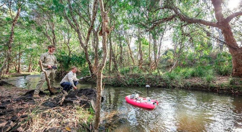
WQI team members working on Mulgrave River. Image courtesy of the Queensland Government
In research just published in PLOS One, the ACEMS team developed statistical tools to take that turbidity and conductivity data and predict levels of sediments and nutrients in the water.
“They’re really the key things water agencies are looking for, both in what their values are and how they are changing over time,” Dr Leigh said.
The sensor data were provided by the Water Quality and Investigations (WQI) Team with the Queensland Department of Environment and Science. By being able to predict levels of sediment and nutrients, managers can look toward automating the sensor process.
“Right now, someone has to physically go to where the monitoring station is, get a sample, take it back to a lab and test it. If we can automate this process with the sensors, we can get a lot more frequent predictions of what’s happening,” Dr Sevvandi Kandanaarachchi, an ACEMS Associate Investigator in the Department of Econometrics and Business Statistics at Monash University said.
“Predicting these quantities is important because if they suddenly change, then that’s an indication that something with the system needs to be looked into.”
Dr Leigh hopes the project will lead to the deployment of many more low-cost sensors. She also says they’re looking into developing an app that farmers and other landowners can use.
“They’re keen to make sure they’re not wasting nutrients, that what they use is taken up by the plants on the land and not end up in a stream,” Dr Leigh said. “They’re also keen to reduce land erosion.”
In work published earlier this year, the ACEMS and WQI teams showed how to detect anomalies in the sensor data. In other words, they needed ways to show if a sensor wasn’t working properly.
“You want to know that the data you’re collecting is good before you go and predict something else,” Dr Leigh said.

Drone image of Mulgrave River. Image courtesy of the Queensland Government
This new research will also help answer questions like where to place the sensors, how many are needed in certain places, and whether they need to be moved around.
“The big picture is making sure certain things that could hurt the reef and our rivers don’t end up in a stream. If they do, that we can act in a timely fashion to figure what’s happening and why,” Dr Leigh said.