

- Consulting firm Johnson, Mirmiran & Thomson (JMT) leveraged InfoDrainage to ensure improvements to the Low Battery Seawall in Charleston will protect the surrounding community from future flooding.
Charleston has benefitted and suffered from an abundance of water since its founding over 350 years ago on a marshy peninsula along the Eastern Seaboard. Although being surrounded by water brought plenty of trade and commerce, the low elevation, wet weather conditions, and proximity to the sea have plagued the historical city with drainage and flooding issues.
Soon after the city was founded, many marshes and creeks were backfilled and removed as part of the city’s development on the downtown peninsula, which has exacerbated the city’s flooding issues over time. Waterways can be filled in and given a new purpose, but once the work has been completed, water always seems to want to return to its original course.
While this was a completely standard practice of the past, today’s water management experts are realizing how problematic this was, which has encouraged them to turn to more nature-based solutions. Experts like JMT are now thinking more flexibly and holistically about their designs, planning with more precise tools and paying close attention to the future implications of their choices.
Holding back the years
Charleston has traditionally counteracted the incursion of high tidal seawater and weather-related water level swings by constructing seawalls and bulkheads along its coast, which have largely been successful. The Charleston Peninsula’s southern boundary is fortified by The Battery, a seawall that overlooks the Charleston Harbor. The Battery consists of two sections that converge at a point where the High Battery and Low Battery seawalls meet.
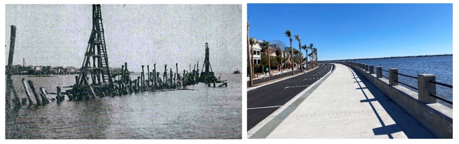
The original concrete seawall was constructed in two phases, with the High Battery Seawall starting in the 1850s and the Low Battery Seawall being completed around 1909. The original concrete wall of the Low Battery was constructed on a timber deck supported by timber pilings in the middle of the Ashley River. Thousands of cubic yards of the riverbed were then pumped behind the wall to build up the peninsula and form the land, which is now mainly residential homes.
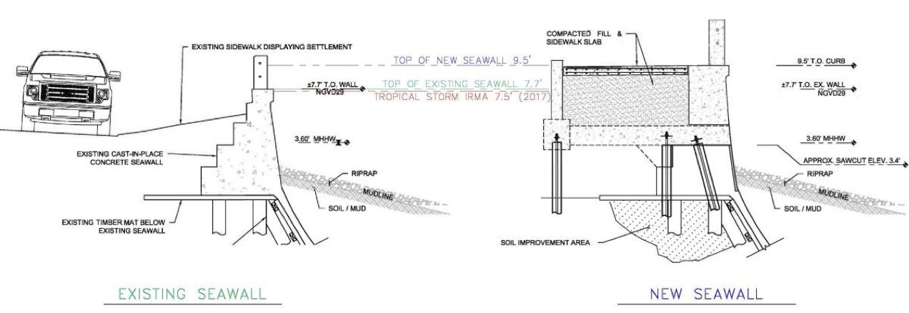 A profile view of the existing seawall and the new seawall.
The seaward face of the Low Battery was skirted with concrete panels attached to timber sheeting and battered piles, which formed a retaining wall system to retain the land-side fill. In total, the corridor stretched nearly 5,800 feet along the tip of the Charleston peninsula, but this timber foundation deteriorated over time, with the roadbed and walkway behind the wall beginning to settle.
After protecting the city against tidal cycles and storm surges for more than 100 years, in 2004 the city began evaluating its condition and flagged the Low Battery Seawall section as requiring significant repairs. These evaluations resulted in the city repairing a section of the wall near Whitepoint Garden referred to as the “Turn”. This work revealed the true extent of the condition of the wall, and the city decided a plan needed to be put into place to repair the remainder of the Low Battery Seawall.
In 2015, JMT was contracted to begin designing the Low Battery Seawall with improvements that would serve several purposes: rehabilitate and upgrade the existing seawall, provide increased public waterfront space and enhancements to the promenade, and road and drainage improvements that would protect the city from more frequent major storm events and higher tidal events. Since sea levels are anticipated to rise an additional 2.5 feet over the next 50 years, the project team wanted to design the new seawall to protect residents and the historic charm of Charleston by adhering to a design life of another 100 years or more.
The timber and concrete wall stood the test of time for 100 years. It’s ready for 100 more.
JMT offered the city several rehabilitation alternatives, from a full replacement to varying degrees of restoration to meet the city’s goals and budgets. One of the desired outcomes was to incorporate improved flood protection into the new design, and JMT, along with their geotechnical subcontractor Schnabel Engineering, developed an innovative and cost-effective micropile option allowing the wall’s original concrete base to be reused, preserving a portion of the historical wall. To help satisfy flooding concerns, and in keeping with the city’s sea-level rise strategies, a vertical extension to the wall was also proposed to allow the overall height to be raised to match the existing High Battery Seawall elevation.
High-tech tools for restoring the seawall
JMT is an employee-owned architecture, engineering, and construction firm that’s been in business for over 50 years. They’ve long been driven by innovation and have a “great willingness to embrace new technologies,” as JMT Design Software Support Agent Michelle Hood puts it.
When JMT’s team was tasked with raising the Low Battery Seawall and improving the capacity of the storm drain systems, which have outlets along the adjoining Ashley River, they chose to utilize Civil 3D as their core design tool for the wall and supporting infrastructure. The goal was to ultimately increase the wall height by 2 feet, raising it to an elevation of 9.5 (NGVD 29). They designed the wall to accommodate the U.S. Army Corps’ vulnerability study of sea level in the area, which would raise the wall (filling in the open railings) an additional 1.5 feet. The project is now in its fourth and final construction phase.
Given historic Charleston’s unique drainage challenges and the importance of improved drainage in the overarching project, JMT’s modeling team chose InfoDrainage for the stormwater drainage design portion of the project. With InfoDrainage’s close integration with Civil 3D, they found the software easy to implement into their design cycle for the project.
Measuring the highs and lows of the tides
In the early phases of the project, the design team was able to evaluate the drainage conditions on-site using InfoDrainage by conducting two tailwater analyses, one at Mean Higher High Tide (MHHW) and one at a tidal elevation 2.5 feet higher than MHHW to accommodate for sea level rise and storm surge.
Most of Charleston’s drainage issues are due to its high tidal swings and heavy rain events, causing significant portions of the drainage infrastructure to be almost full during high tide. This meant that the site conditions could swing drastically between their two models. “Being able to bounce between the two tidal phases by only changing the boundary conditions inside of InfoDrainage was extremely helpful,” says JMT Project Engineer Andrew Carrier.
The ability to clearly visualize water flow and conditions inside InfoDrainage assisted the design team and enabled them to share the work with a multitude of highly interested stakeholders, particularly residents adjoining the seawall. “How do we explain to the residents that their car tyres will be underwater?” Carrier asks rhetorically. “With InfoDrainage, you can easily show that when presenting to clients and city officials. InfoDrainage’s graphical profiles made getting customer buy-in and approval way easier.”
Hydrologically speaking, JMT’s two main driving forces affecting their drainage system designs were increased rainfall and higher tailwater conditions on the wall. With InfoDrainage, they could mitigate and model these constraints, designing a system of drainage pipes and valves to combat sea level rise and provide resilient infrastructure for the city. They leveraged InfoDrainage’s built-in HEC-22 sizing tools for inlet-specific features to determine drainage spread and made preliminary pipe sizing estimates using the model.
Staying connected with InfoDrainage + Civil 3D
“The biggest challenge is having no longitudinal grade,” says Carrier. In other words, the city is incredibly flat. The level site makes solving drainage challenges even more difficult, but the Civil 3D integration with InfoDrainage helped them collaboratively plan with precision to achieve the most out of both applications.
JMT smartly relies on a custom library of parts inside Civil 3D, which includes customized SCDOT and city structures, so their drainage design software needs to integrate with Civil 3D as seamlessly as possible to avoid rework and reformatting. “With our Civil 3D standards, everything is in there as we need it, and you can pull that directly into InfoDrainage, bringing everything over through the ribbon,” says Carrier.
Additionally, as part of the project, JMT’s hydraulic design team leveraged NOAA ATLAS 14 and local rainfall data, incorporating this into InfoDrainage models with the built-in rainfall distribution tool. Leveraging this with an increased 10% safety factor, the team was able to develop accurate and safe stormwater models for the project, ensuring that the built infrastructure implemented as part of the $64 million project was up to spec for many years to come.
A bigger wall – and a better drain
The design of the Low Battery Seawall will protect Charleston from high tidal swings for many years to come. By raising the elevation of the seawall, the impact of storm surge events based on historical models can be heavily mitigated. Only two storms in recorded history have created a surge that would overtop the new seawall, Hurricane Hugo in 1989 and a large storm from 1940.
However, even in these types of events, JMT’s drainage design ensures that the flooding will only be temporary. As the City of Charleston notes in an ArcGIS Storymap they created for the project, “The increased size of the newly installed storm drains means the Battery will drain quickly when the tide subsides.” This outcome was achieved thanks to the expert team at JMT and the modelling capabilities of InfoDrainage, showing that a willingness to embrace new technologies can quickly make an impact in drainage design and streamline the modelling process, delivering much-needed improvements to one of America’s most historic cities.


